High-speed, 3-D image reconstruction method that exceeds the limit in spatial resolution and accuracy (RPM method)
Conventional imaging radar technology is mainly based on synthetic aperture processing and time back propagation,
and thus requires a large amount of computation to achieve high-resolution imaging, especially for 3-D problems.
In addition, the spatial resolution is at best half of the wavelength, and even 5 GHz band UWB radar has a spatial resolution of about 3 cm.
On the other hand, the radar technology that we have independently developed, by specializing in target boundary extraction,
increases the processing speed by a factor of several thousand and, through frequency interferometry that takes full advantage of the ultra-wide bandwidth of the UWB signal, a
chieves ultra-high resolution images (with a resolution of 1/10 of the wavelength and a positioning accuracy of 1/100 of the wavelength) that exceed the wavelength limit.
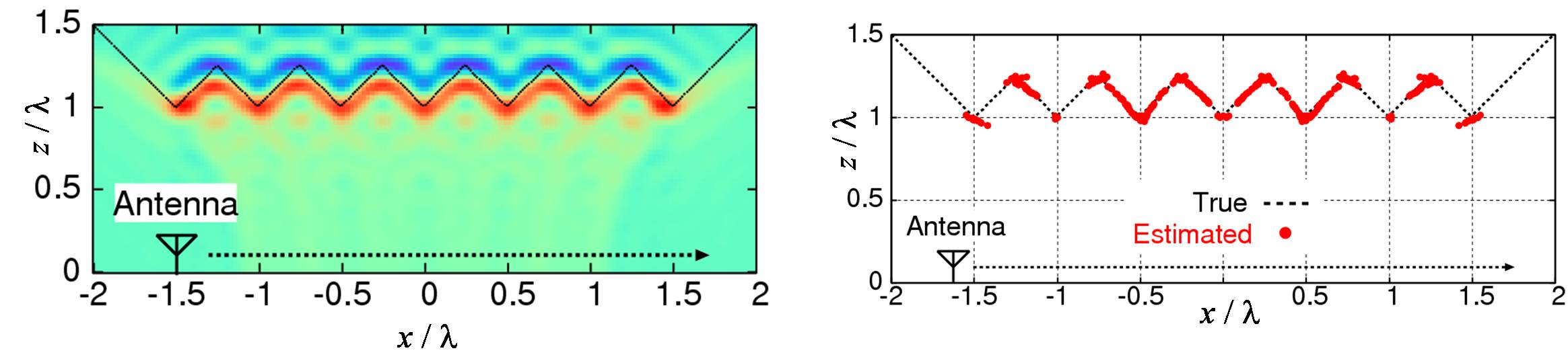
This is called Range Points Migration (RPM). This is called the Range Points Migration (RPM) method. Figure 1 shows an example of synthetic aperture processing (SAR)
and the RPM method for a two-dimensional problem. With conventional SAR, the spatial resolution is limited by the wavelength,
which prevents the reproduction of clear boundaries and the detection of edges and other features of the target.
In contrast, the RPM method reproduces the target as a point cloud by extracting the boundary using only distance information,
and thus retains the spatial resolution of super wavelength resolution as long as the distance information is accurately obtained.
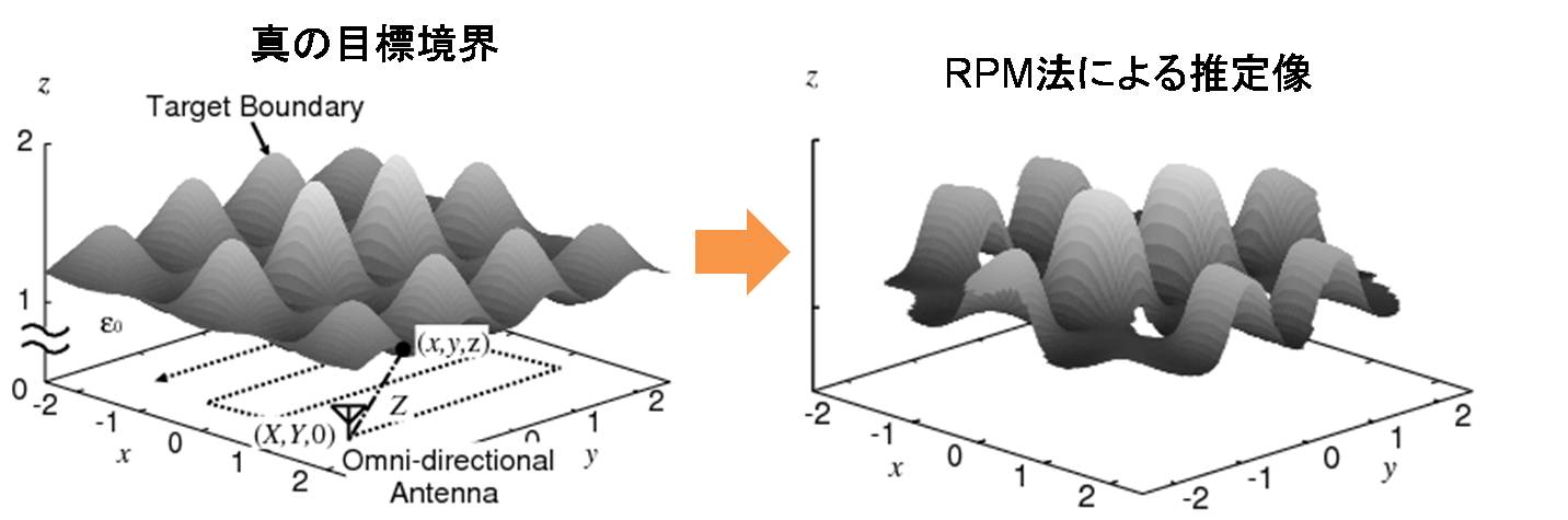
Figure 2 shows an extension of the RPM method to a three-dimensional problem, which can also reproduce uneven surfaces on a scale smaller than the wavelength.
Future Prospects:
Based on these theories, this research theme is conducting world-leading research by setting challenging problems such as imaging moving targets whose motion and shape are completely unknown, and under conditions where a large observation area is not available.
[1] Shouhei Kidera, Takuya Sakamoto and Toru Sato,
"Super-Resolution UWB Radar Imaging Algorithm Based on Extended Capon
with Reference Signal Optimization",
IEEE Trans. Antennas & Propagation, vol.59, no. 5, pp.~1606--1615, May, 2011.
[2] Shouhei Kidera, Takuya Sakamoto and Toru Sato,
"Accurate UWB Radar 3-D Imaging Algorithm for Complex
Boundary without Range Points Connections",
IEEE Trans. Geoscience and Remote Sensing,
vol.48, no. 4, pp.~1993--2004, Apr., 2010.
[3] Shouhei Kidera, Takuya Sakamoto and Toru Sato,
"High-resolution and Real-Time 3-D Imaging Algorithm
with Envelope of Spheres for UWB Radars" ,
IEEE Trans. Geoscience and Remote Sensing, vol.46, no.11, pp.3503--3513,
Nov, 2008.
[4] Shouhei Kidera, Takuya Sakamoto and Toru Sato,
"A robust and fast imaging algorithm with an envelope of circles
for UWB pulse radars",
IEICE Trans. Commun., vol.E90-B, no.7, pp. 1801--1809, Jul, 2007.
[5] Shouhei Kidera, Takuya Sakamoto and Toru Sato,
"A high-resolution imaging algorithm without derivatives
based on waveform estimation for UWB pulse radars
IEICE Trans. Commun., vol.E90-B, no.6, pp.1487--1494, Jun, 2007.
Future Prospects:
Based on these theories, this research theme is conducting world-leading research by setting challenging problems such as imaging moving targets whose motion and shape are completely unknown, and under conditions where a large observation area is not available.
Figure 1: Reconstruction results (Left: SAR, Right: RPM)
Figure 2: 3-D reconstruction image (Left: Ground truth, Right: RPM)